Exploring Gillespie Point Scenic Overlook in Tioga County

This is a collage of five photos from Gillespie Point scenic overlook along the Mid State Trail in Tioga County, Pennsylvania. The central image features a hiker in a red jacket and brown boots, using a walking stick, standing on rocky terrain and looking out over a valley with leafless trees and a winding river. The top-right image showcases a verdant moss-covered trail leading through bare trees. The bottom-left image depicts a serene river curving through a forested valley. The bottom-middle photo offers a wide view of a valley with coniferous and deciduous trees and distant hills under a partly cloudy sky. Finally, the bottom-right image is of a wooden signpost with

If you’re looking for information about Gillespie Point scenic overlook in Tioga County, you’re in the right place!

Elevated view from Gillespie Point overlooking a meandering Pine Creek cutting through the forested valley of Tioga County, Pennsylvania. The landscape is a mix of leafless deciduous trees and scattered evergreens, typical of the late fall or early spring season. The river and adjacent rural road are flanked by the rolling hills of the Appalachian region, under a sky streaked with clouds.
Pine Creek meandering south towards Cedar Run.

Nestled in the heart of Pennsylvania’s “Grand Canyon” area, Gillespie Point, also known as “The Matterhorn of Pennsylvania,” offers breathtaking views of the Pine Creek Gorge and a rewarding hiking experience.

A stunning view from Gillespie Point scenic overlook, with a solitary evergreen tree prominently in the foreground. The tree stands tall among a forest of bare deciduous trees, overlooking the vast Pine Creek Gorge in Tioga County, Pennsylvania. The undulating hills roll into the distance under a sky dotted with fluffy white clouds, showcasing the natural splendor of the region as seen from the Mid State Trail.
View to the north.

Hiking to Gillespie Point scenic overlook along the Mid State Trail is an adventure that combines natural beauty, physical challenge, and the peacefulness of the great outdoors.

A panoramic view from Gillespie Point scenic overlook, showcasing the sweeping landscape of Tioga County, Pennsylvania. The forefront features a rocky outcrop with a scattering of young, leafless trees and evergreens, while a river meanders through the valley below, flanked by rolling, forested hills that fade into the horizon under a partly cloudy sky.
Panoramic view from Gillespie Point.

The Hike to Gillespie Point

The hike to Gillespie Point as described here covers roughly 2.5 miles out and back, all of it along the orange-blazed Mid State Trail.

A topographic trail map showing the hiking trail leading to Gillespie Point scenic overlook in Tioga County Pennsylvania.
Gillespie Point trail map.

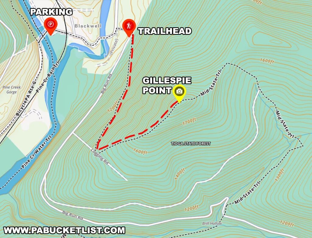
The hike begins at a paved parking lot along Pine Creek in the village of Blackwell.

A bright orange Toyota Tacoma pickup truck is parked in a deserted asphalt parking lot near Gillespie Point in Tioga County, Pennsylvania. Leafless trees and evergreens border the area, with a bridge crossing Pine Creek visible in the background. The landscape is indicative of late fall or early spring, with a clear blue sky overhead and a backdrop of gentle hills in the distance, suggesting the peaceful seclusion of the area along the Mid State Trail.
Parking lot in Blackwell along Pine Creek.

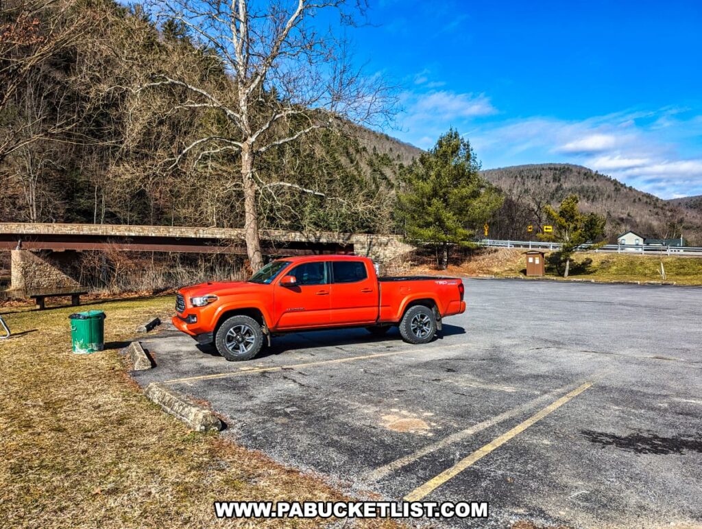
If navigating by GPS coordinates, use 41.55608, -77.38197 to locate the parking lot.


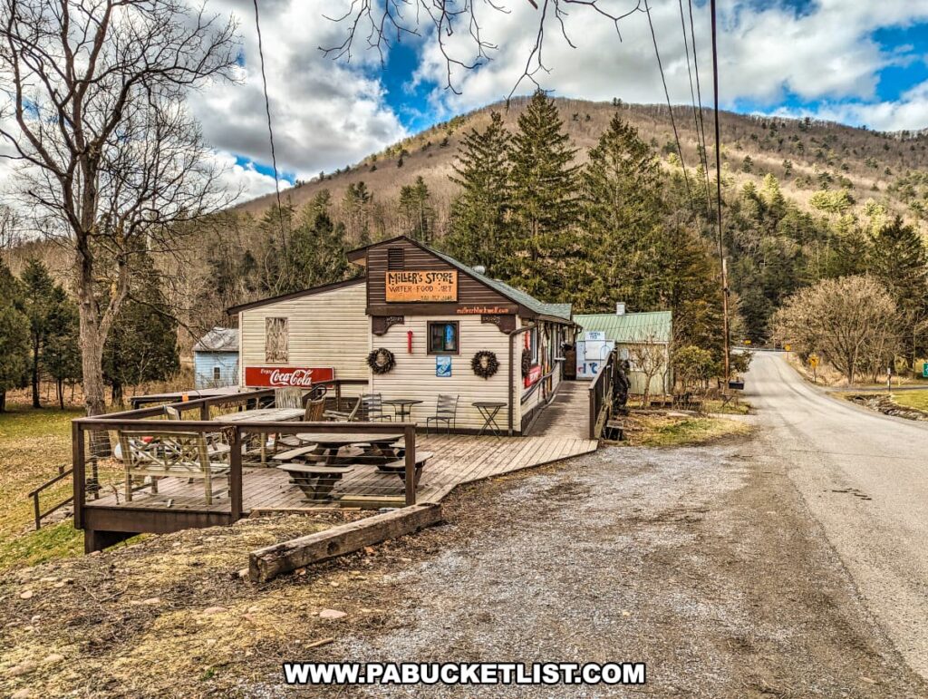
From the parking lot, you’ll walk east along the edge of Route 414 for a 1/4 mile to Big Run Road, passing Miller’s Store along the way (a great spot to grab snacks/drinks before or after your hike.)

Rustic charm of Miller's Store in Blackwell, Tioga County, Pennsylvania, captured on a bright day with a backdrop of hills and evergreen trees. The store features a wooden facade with vintage Coca-Cola signage, situated beside a quiet country road. A welcoming outdoor deck with picnic tables invites visitors to rest, while the surrounding bare trees suggest late fall or early spring. Power lines extend above, highlighting the blend of nature and rural community life along the Mid State Trail.
Miller’s Store in Blackwell.

Just past Millers store you’ll cross over an open-grate bridge over Babb Creek.

A view of a rural open grate bridge in Blackwell, Tioga County, Pennsylvania, leading towards a collection of cabins nestled among leafless trees. The metal bridge features a sturdy guardrail and a patterned surface allowing views of the creek below. The landscape suggests early spring or late fall, with a hilly backdrop, a mix of evergreen and bare deciduous trees, and a partly cloudy sky. Shadows from the bridge's railings stripe the road, adding texture to the scene near the Mid State Trail.
Open grate bridge over Babb Creek.

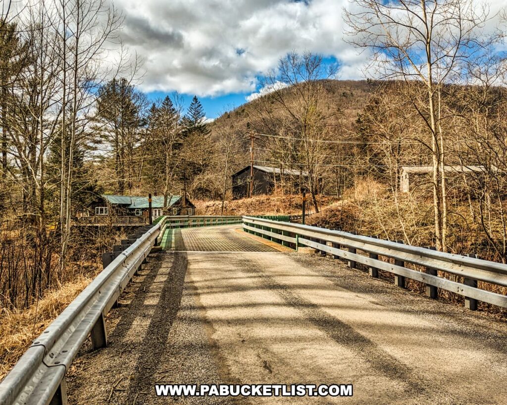
Once across the bridge, hang a right on Big Run Road (a “No Winter Maintenance” forest road).

Intersection of Route 414 and Big Run Road near the Gillespie Point trailhead in Blackwell PA.
Intersection of Route 414 and Big Run Road near the Gillespie Point trailhead.

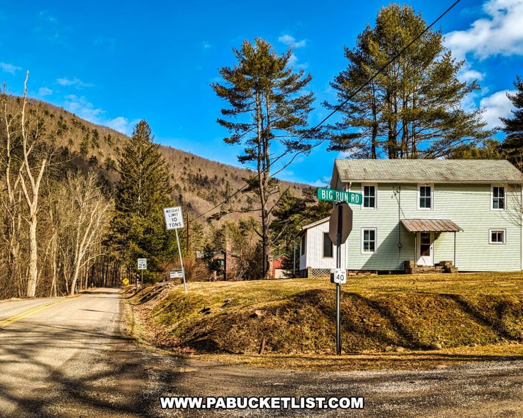
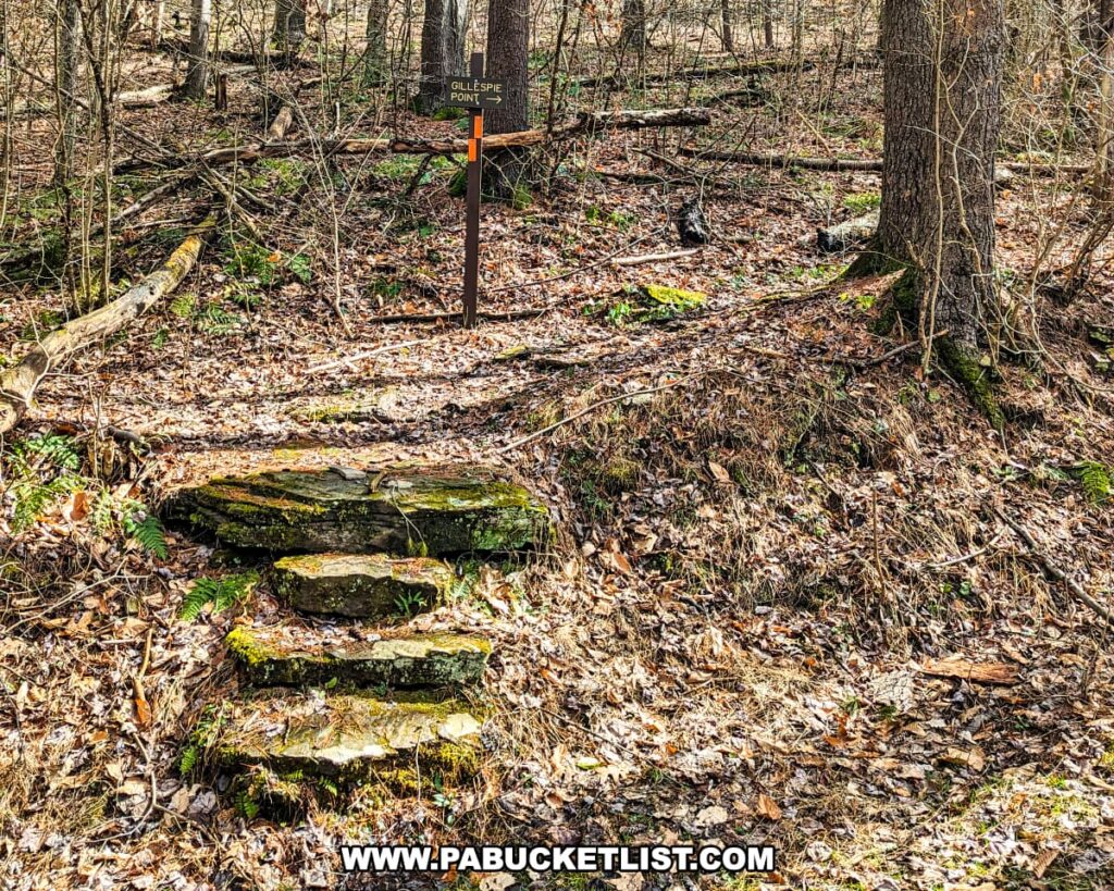
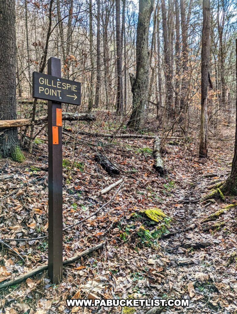
The trailhead will be on the left side of Big Run Road when facing uphill.

A trail sign for Gillespie Point, set amidst a natural woodland scene in Tioga County, Pennsylvania. The trail, part of the Mid State Trail, is marked by a brown sign with white lettering, pointing to the right. The ground is covered with fallen leaves, indicative of either autumn or spring, and the forest floor is dappled with sunlight. A series of moss-covered stone steps lead up through the leaf-littered terrain, surrounded by bare deciduous trees and a few evergreens.
Trailhead along Big Run Road.

There are narrow spots on either side of the road near the trailhead where you could, in theory, park for this hike.

The beginning of the trailhead for the Gillespie Point hike on the Mid State Trail in Tioga County, Pennsylvania, with pull-off parking available on either side of Big Run Road. The gravel road bends gently in the forested landscape, surrounded by bare deciduous trees with a hint of green moss and undergrowth starting to show, indicating early spring.
Narrow pull-off parking along Big Run Road.

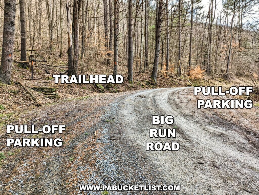
If you choose to do so (assuming there is space available), you’d save yourself roughly a 1/4 mile each way out and back.

A trail sign indicating 'GILLESPIE POINT' with an arrow pointing right, located along the Mid State Trail in Tioga County, Pennsylvania. The sign stands amid a forest floor covered with fallen leaves, with moss-covered rocks and a variety of slender, leafless trees in the background, all under soft, dappled sunlight.
Gillespie Point directional sign.

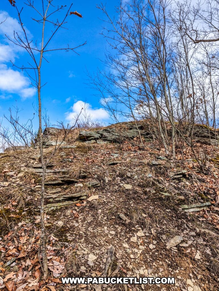
From Big Run Road, the hike up to Gillespie Point covers 0.9 miles and roughly 900 feet of elevation gain.

A narrow hiking trail meanders through a forested area in Tioga County, Pennsylvania, part of the Mid State Trail near Gillespie Point. The trail is carpeted with fallen leaves and a streak of green moss, lined with tall, leafless trees awaiting spring. An orange blaze on a tree provides guidance for hikers.
Mid State Trail headed uphill towards Gillespie Point.

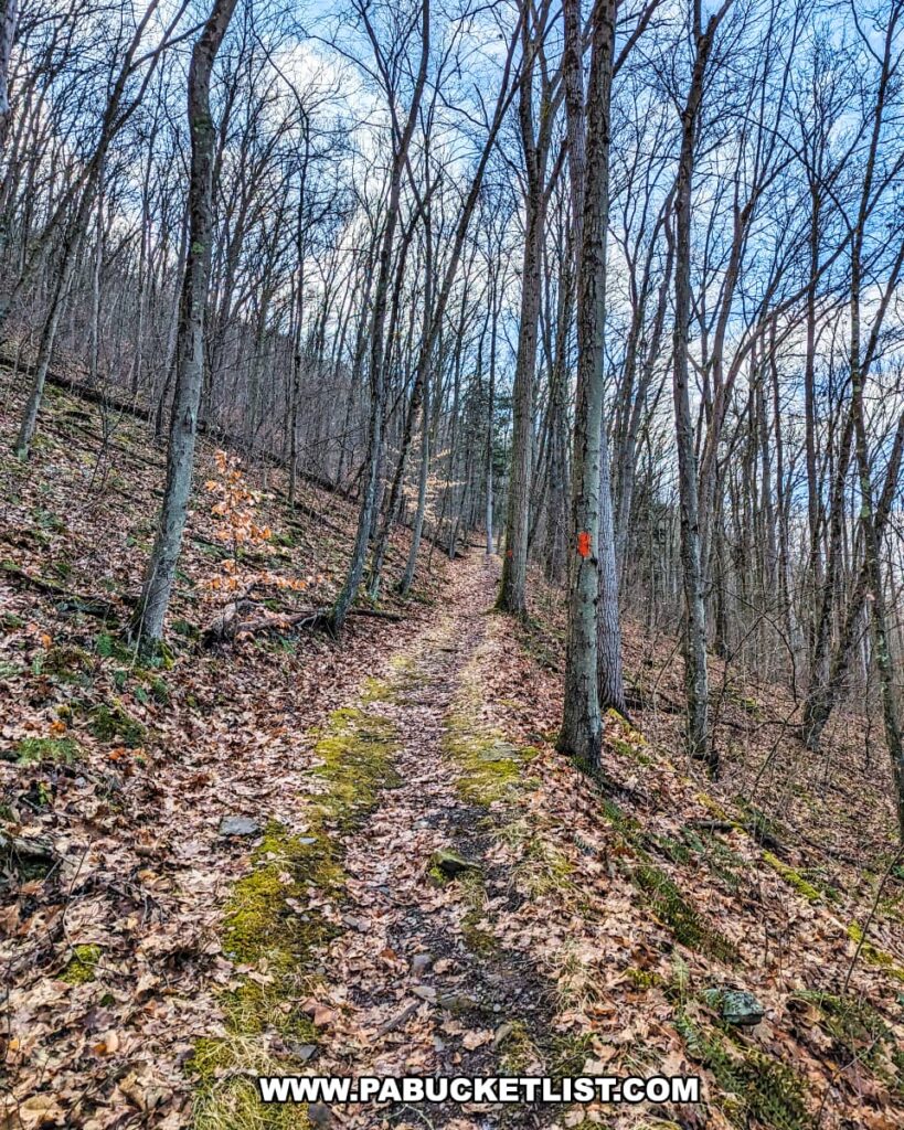
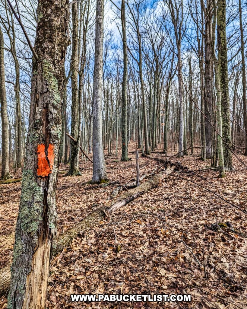
The entire hike, as mentioned previously, follows the orange-blazed Mid State Trail.

A tranquil trail scene along the Mid State Trail in Tioga County, Pennsylvania, featuring a trail marker for the Mid State Trail (MST). The marker is a wooden post with 'MST' and an upward arrow painted in white, set against a background of leaf-covered ground and a variety of trees, some with bare branches and others with evergreen needles. An orange blaze is visible on a tree trunk, guiding hikers along the path that disappears into the serene woodland.
Mid State Trail sign.

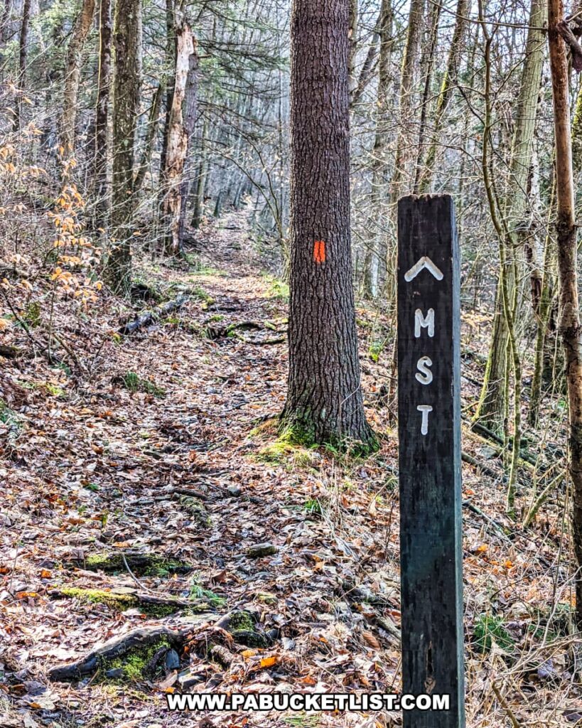
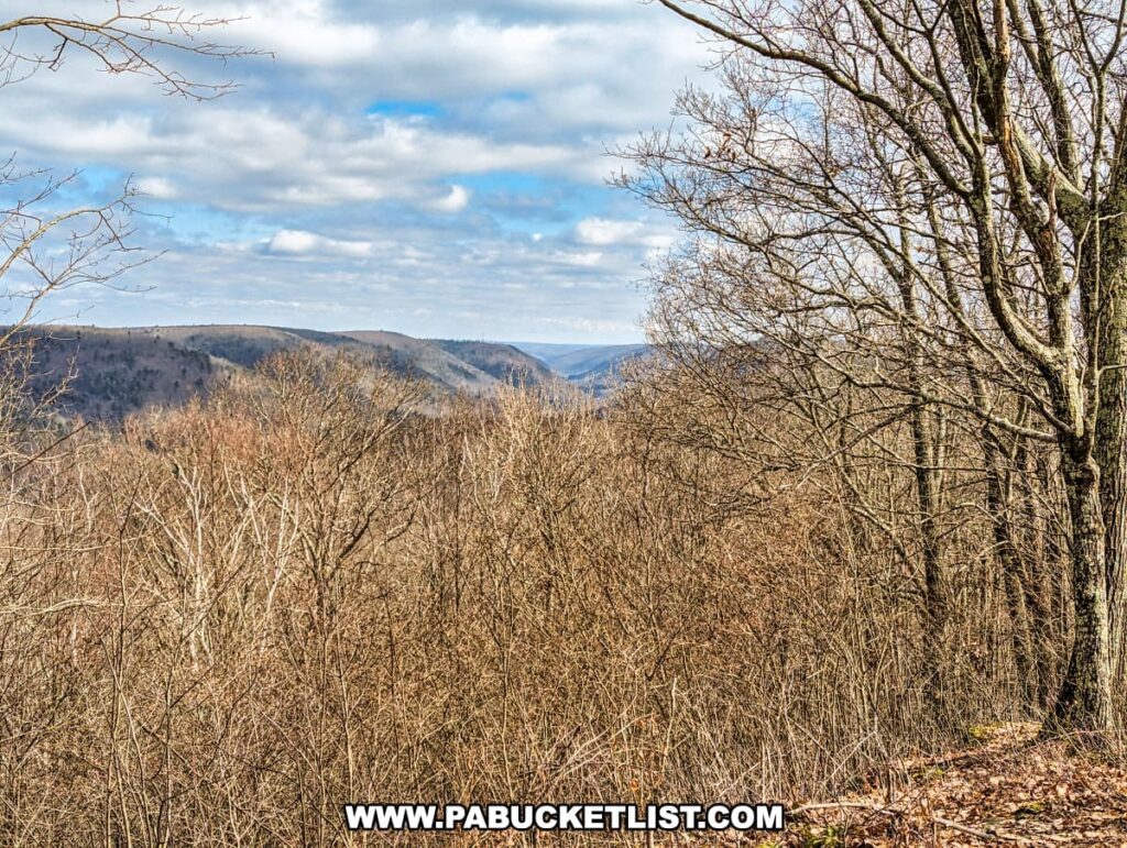
The trail is well-worn, well-blazed, and there are really no “technical sections” – it’s simply a rather steep uphill walk through open woods.

The Mid State Trail in Tioga County, Pennsylvania, marked by a prominent orange blaze on a tree trunk, winds through a dense, leafless hardwood forest. The ground is covered in a thick layer of brown leaves, with occasional green moss patches visible. The forest has a stark, quiet beauty, indicative of the cold months when trees are dormant
Orange blaze along the Mid State Trail.

Hiking at a leisurely pace and stopping to take a few photos along the way, I reached Gillespie Point from my parking spot along Pine Creek in 45 minutes.

The rugged terrain of a trail just below Gillespie Point on the Mid State Trail in Tioga County, Pennsylvania. The ground is strewn with fallen leaves and small rocks, leading up to a steep rocky outcrop. Leafless trees frame the bright blue sky, suggesting it could be late fall or early spring. The scene captures the challenging and natural beauty of the trail, inviting hikers to explore further.
Approaching the vista.

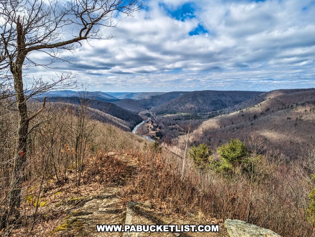
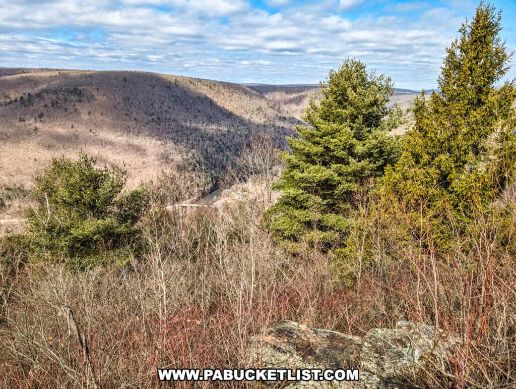
The Views from Gillespie Point

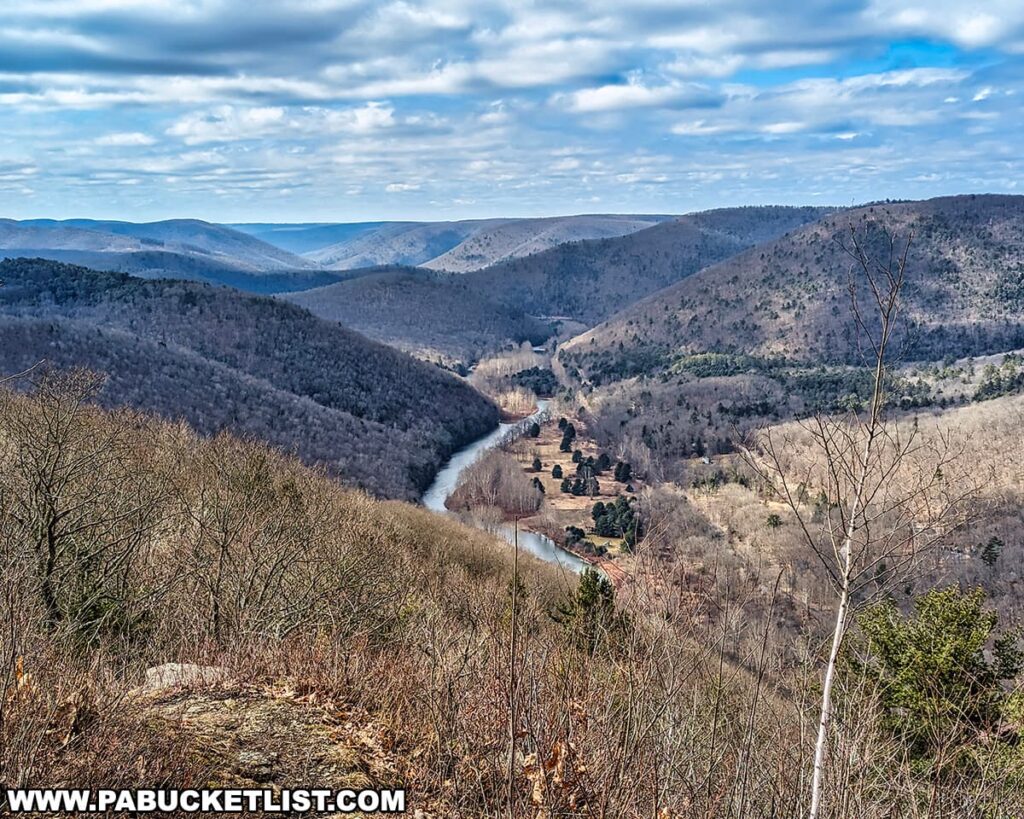
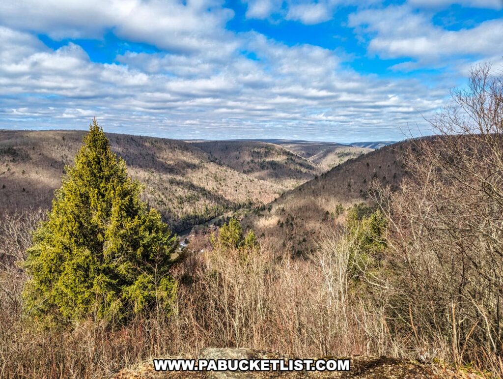
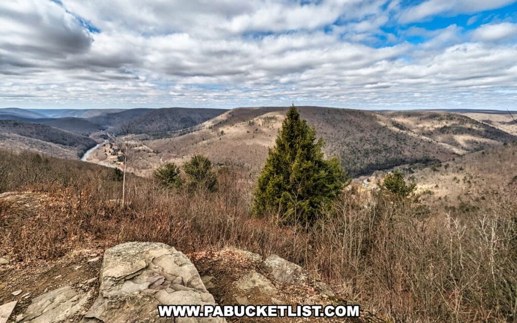
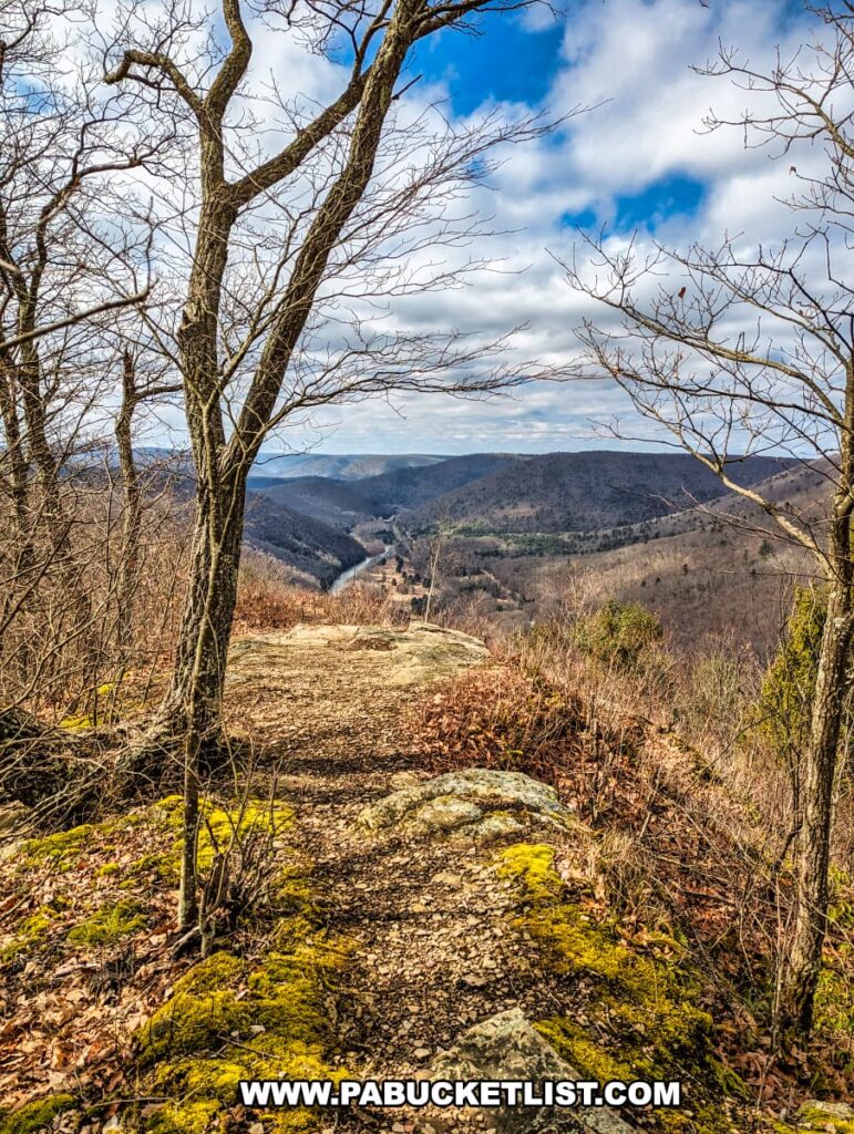
The climax of the hike is the arrival at Gillespie Point, located at GPS coordinates 41.55225, -77.37220.

A hiker stands at the edge of Gillespie Point scenic overlook on the Mid State Trail in Tioga County, Pennsylvania. The overlook provides a panoramic view of a river valley with forested rolling hills stretching into the distance. The hiker, in profile from behind, gazes out over the landscape while leaning on a walking stick. They wear a red jacket, gray pants, and brown hiking boots. The sky is partly cloudy, suggesting a cool or mild weather. The bare trees indicate it might be late fall or winter. The terrain at the overlook is rocky with some grass and low shrubs, typical of a well-traveled hiking trail.
The author at Gillespie Point in early March.

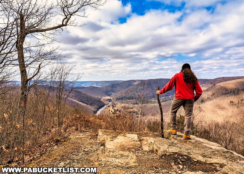
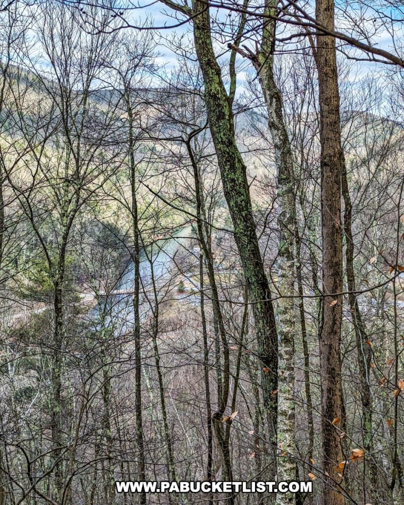
Standing at an elevation of 1,884 feet above sea level, this vantage point offers unparalleled views of the Pine Creek Gorge, affectionately known as Pennsylvania’s Grand Canyon.

Lush evergreen tree stands prominently against a backdrop of rolling hills in Tioga County, Pennsylvania, as seen from Gillespie Point scenic overlook. The hills are covered with bare deciduous trees, suggesting the transition between seasons. The vast landscape opens under a partly cloudy sky, offering a stunning view that exemplifies the natural beauty along the Mid State Trail.
View to the north over Blackwell.

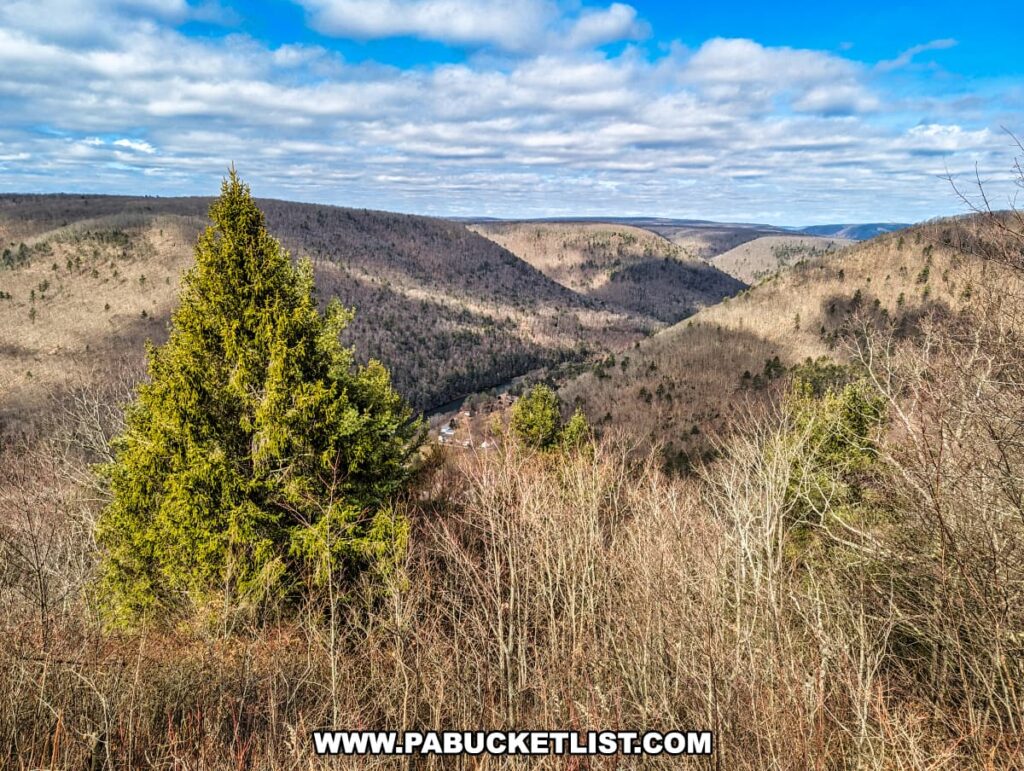
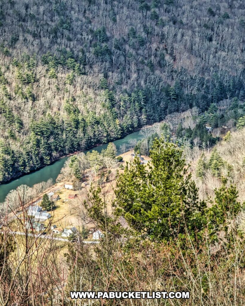
The panoramic vista includes rolling hills, lush valleys, and the winding Pine Creek, all coming together in a spectacular display of nature’s artistry.

A breathtaking panoramic view from Gillespie Point scenic overlook along the Mid State Trail in Tioga County, Pennsylvania. This vista showcases a vibrant evergreen tree in the foreground, standing out against the muted colors of the surrounding leafless deciduous trees. A river snakes through the valley below, cutting between rolling hills that stretch into the distance under a dynamic sky of white clouds scattered across the blue. The landscape is a stunning display of natural beauty, typical of the Appalachian region.
Panoramic view from the overlook.

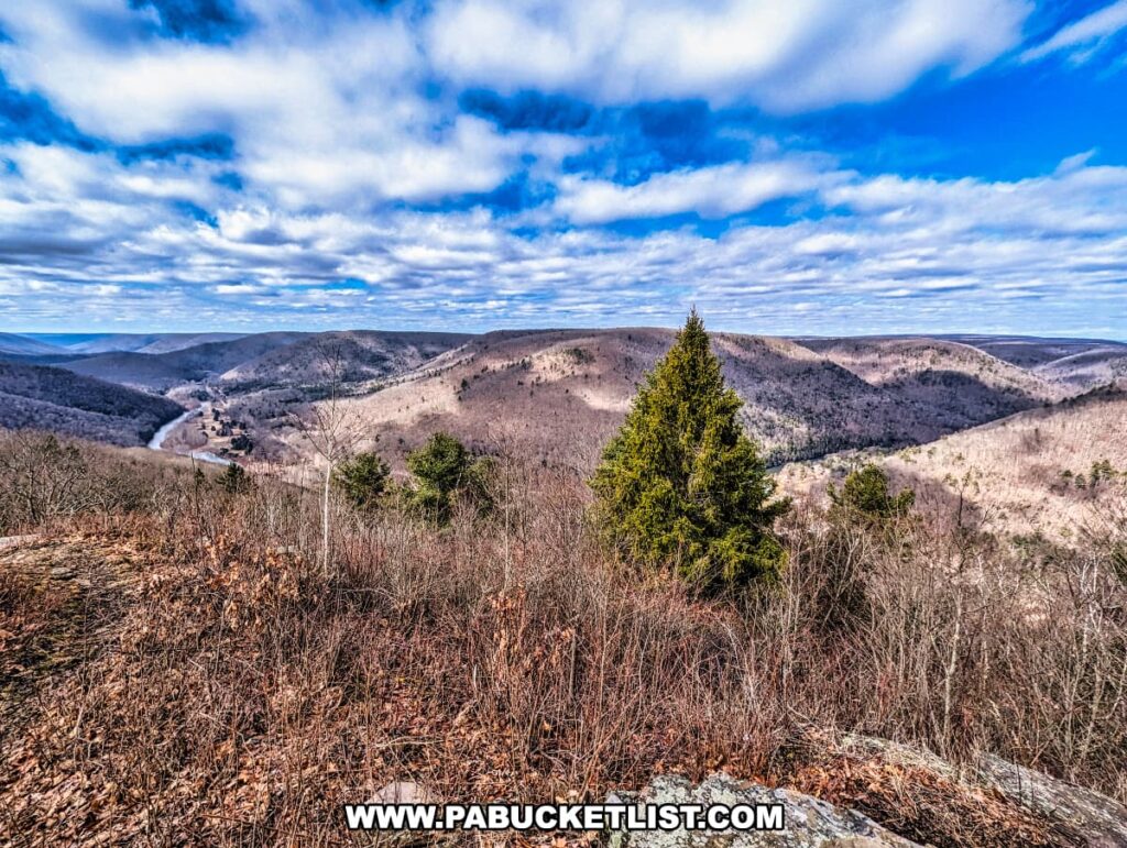
Directly below you lies Blackwell, where your hike started.

An elevated view of Pine Creek winding through a densely forested area in Tioga County, Pennsylvania, with a cluster of houses nestled in the valley. The river is framed by the contrasting textures of evergreen and leafless deciduous trees, signifying a change of seasons. This perspective from Gillespie Point scenic overlook also captures the tranquility of the rural landscape found along the Mid State Trail.
Looking down in to Blackwell.

To the northeast, you have a partial view of the Babb Creek Valley.

A view through the dense, leafless branches of a forest in late fall or early spring at Gillespie Point, looking towards the east along the Mid State Trail in Tioga County, Pennsylvania. The barren trees reveal the rolling hills of the distant landscape, partially obscured by the forest canopy. Above, the sky is a bright mix of blue and cloud, hinting at the changing seasons in this scenic wilderness area.
Looking out over Babb Creek Valley.

The trek up the “Matterhorn of the Alleghenies” to savor the expansive panorama spread out below truly is worth the effort.

A mossy section of the Mid State Trail at Gillespie Point scenic overlook, with a stunning view of the rolling hills of Tioga County, Pennsylvania. The trail is bordered by leafless trees and covered with a mix of rocks and patches of green moss, suggesting the season might be early spring. The path leads the eye toward the distant hills under a partly cloudy sky, offering hikers a sense of adventure along the trail.
Beds of moss at the vista.

When you’ve had your fill of Gillespie Point, simply retrace your steps back down the Mid State Trail.

Looking through a natural window of thin, bare trees on the Mid State Trail near Gillespie Point in Tioga County, Pennsylvania, a glimpse of a serene river can be seen in the valley below. The trees' trunks are adorned with lichen and the last of the autumn leaves cling to the branches, hinting at the quiet transition into winter.
Window through the trees along the trail – note the bridge next to the parking area in the background.

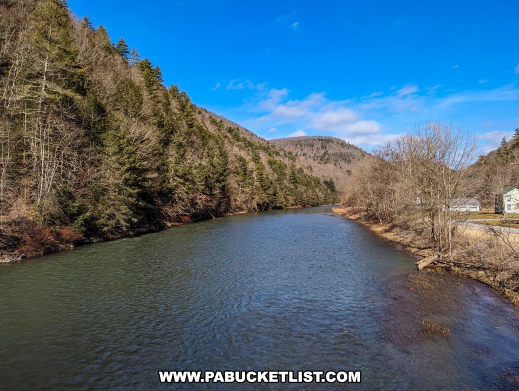
Back at the parking area, take time to check out the views along Pine Creek.

A wooden sign reading 'Pine Creek Pennsylvania Scenic Rivers System' positioned against a tree with a scenic backdrop of Pine Creek and a covered bridge in Tioga County, Pennsylvania. The creek appears calm and reflects the surrounding landscape. Leafless trees and dried leaves on the ground suggest late fall or winter. The image captures the tranquil essence of the area near the Mid State Trail, with a partly cloudy sky above.
Pine Creek next to the parking area.

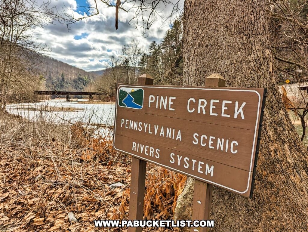
The views from the bridge over Pine Creek along Route 414 are especially nice.

Serene view of Pine Creek meandering through a valley in Blackwell, Tioga County, Pennsylvania, along the Mid State Trail. The creek is flanked by steep, evergreen-covered slopes on one side and a line of bare deciduous trees on the other. A small white building can be glimpsed through the trees on the right bank. The scene is set against a bright blue sky with sparse clouds, highlighting the natural beauty of the area in early spring.
View from the bridge over Pine Creek along Route 414 in Blackwell.

Final Thoughts

The strenuous hike to Gillespie Point rewards those who undertake it with stunning views and a sense of accomplishment.

Expansive view from Gillespie Point overlooking the Pine Creek Gorge in Tioga County, Pennsylvania, as seen from the Mid State Trail. Pine Creek cuts through the heart of the valley, embraced by the undulating hills and leafless trees of early spring or late autumn. The sky is a canvas of white and gray clouds, with patches of blue peeking through, casting dynamic shadows over the landscape. In the foreground, a rocky outcrop with sparse vegetation offers a vantage point over this serene natural scene.
Looking south towards Cedar Run along Pine Creek.

Whether you’re an experienced hiker or a newbie looking for your first big challenge, Gillespie Point offers a memorable experience in the heart of Pennsylvania’s Tioga State Forest.

An elevated view from Gillespie Point scenic overlook, featuring the lush greenery of evergreen trees against a backdrop of rolling, barren hills of Tioga County, Pennsylvania. A glimpse of a road or river can be seen through the trees in the middle distance. The landscape, under a blue sky with scattered clouds, is a testament to the natural beauty found along the Mid State Trail, even in seasons when most trees are without leaves.
While strenuous, this hike is very simple to navigate.

32 Must-See Attractions in Tioga County is your guide to more of the best scenic overlooks, waterfalls, parks, and historic sites near Gillespie Point.

A collage of four photographs showcasing natural attractions in Tioga County, Pennsylvania. The top left image captures a hiker standing on a rocky overlook, gazing out over a lush, deep green valley with a river snaking through it. The top right photograph shows a high perspective of a waterway cutting through a forested landscape with colorful autumn foliage. The bottom left image features a photographer capturing a tall, cascading waterfall surrounded by dense greenery. The bottom right photo depicts a tranquil lakeside scene with a wooden picnic table and bench, a colorful umbrella, and kayaks resting on the grassy shore, with autumn-touched trees reflecting on the still water.
Scenes from Tioga County.

8 Must-See Attractions in Lycoming County is a guide to the best things to see and do in Tioga County’s neighbor to the south.

The Best Things to See and Do in Lycoming County Pennsylvania
Scenes from Lycoming County.

My Scenic Overlooks Guide provides directions to more than 150 of PA’s best vistas and overlooks!


Did you enjoy this article?

If so, be sure to like and follow PA Bucket List on Facebook, Instagram, and/or Pinterest to learn more about the best things to see and do in Pennsylvania!

Click on any of the icons below to get connected to PA Bucket List on social media.


PA Bucket List 2022 Sasquatch Logo

Pennsylvania’s Best Travel Blog!

Rusty Glessner
Rusty Glessner is a professional photographer, lifelong Pennsylvanian, and a frequently-cited authority on PA's best travel destinations.