Exploring the Sunken Highway at Bald Eagle State Park

This collage presents various views of the Sunken Highway at Bald Eagle State Park near Howard, PA. Top left, a figure stands distant on the narrow path beside calm waters. Top right, the highway stretches towards a dam, bordered by a rocky shore and a fisherman in the foreground. Center, the path bisects the lake's expanse under a clear sky. Bottom left, the cracked concrete is framed by the shore. Bottom right, an angler focuses on the tranquil waters, his gear resting on the road. An inset map details the highway’s original route. Together, these images capture the serene beauty and the historical significance of the submerged roadway.

Did you know there’s an abandoned stretch of US Route 220 running beneath Sayers Lake at Bald Eagle State Park?!

A concrete road bisects the placid waters of Sayers Lake, leading into the distance towards rolling hills under a wide blue sky. This is the Sunken Highway at Bald Eagle State Park, usually submerged but now visible, a linear interruption in the natural landscape. Its weathered surface speaks to its history, contrasting with the gentle waves lapping against its sides, a reminder of the lake’s dominance over what was once a bustling route.
The “sunken highway” bisects the placid waters of Sayers Lake in late March.

You heard that right – the original route of US 220 had it running parallel to Bald Eagle Creek near Howard in Centre County.

A 1941 road map of the Howard area showing Old Route 220 running along Bald Eagle Creek before the creek was dammed to build Sayers Lake in the late 1960s.
A 1941 road map of the Howard area showing old US 220 running along Bald Eagle Creek before the creek was dammed to build Sayers Lake in the late 1960s.

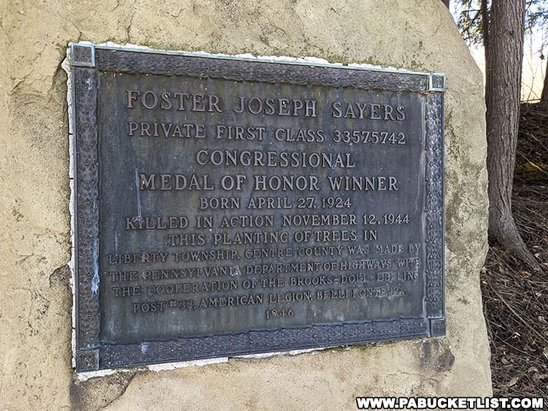
That is until 1969, when the 100-foot high and 1.3 mile long Foster Joseph Sayers Dam was built as a flood control project by the Army Corps of Engineers.

A modern map of Bald Eagle State Park and the Howard area, showing that Route 220 is now gone, sunken beneath Sayers Lake.
On this modern map you can see where US 220 near Howard “vanished” when Sayers Lake/Sayers Dam was constructed.

The dam and the 1,730-acre lake it formed is named in honor of Foster Joseph Sayers, a Private 1st Class machine gunner in the U.S. Army and World War II Congressional Medal of Honor Recipient.

Foster Joseph Sayers Monument at Bald Eagle State Park in Centre County Pennsylvania.
Foster Joseph Sayers Monument at Bald Eagle State Park.

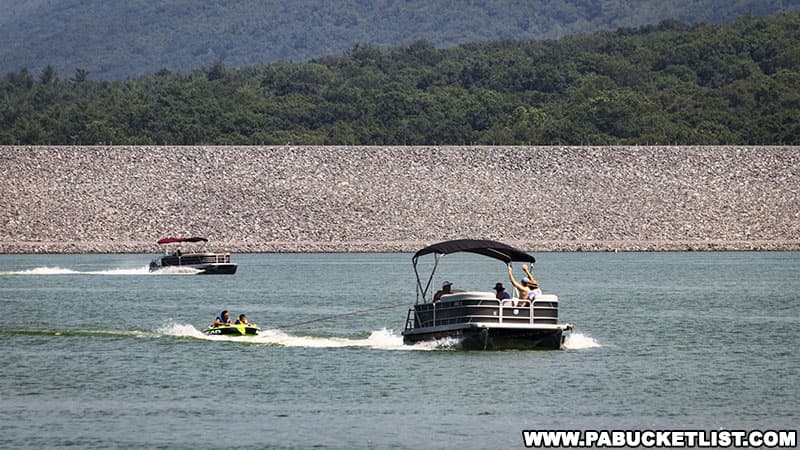
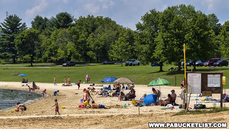
The lake is the focal point for water-based recreation at Bald Eagle State Park.

Tubing on Sayers Lake at Bald Eagle State Park in Centre County Pennsylvania.
Tubing on Sayers Lake near the dam.

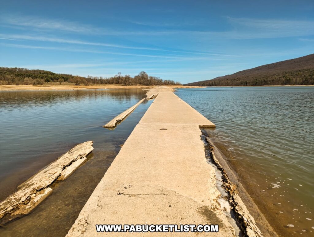
And beneath that lake lies the original US 220, with the current US 220 now running concurrently with Interstate 80 in this part of the state.

The weathered surface of the old Sunken Highway at Bald Eagle State Park is captured here as it stretches between the waters of Sayers Lake. This fragment of Old US Route 220, with its cracks and patches, tells a story of transformation from a busy thoroughfare to a serene walking path. The lake nestles quietly on either side, with a beach visible to the right, leading towards distant hills under a vast blue sky.
The weathered surface of the old sunken highway at Bald Eagle State Park

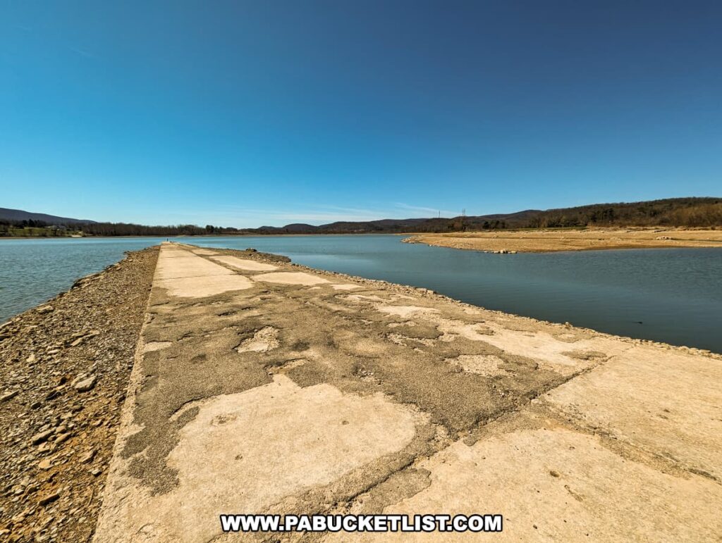
Every winter, for a few months, Sayers Lake is drawn down as a flood prevention measure.

A long, narrow concrete roadway, bordered by rocky edges, extends directly into the horizon on Sayers Lake at Bald Eagle State Park. The clear blue sky above and the calm waters to either side frame the Sunken Highway, which once carried travelers along Old US Route 220. Now, it lies as a silent witness to the past, leading towards the distant township of Howard, Pennsylvania, with a solitary fisherman in the distance enjoying the view.
View towards Howard along the sunken highway.

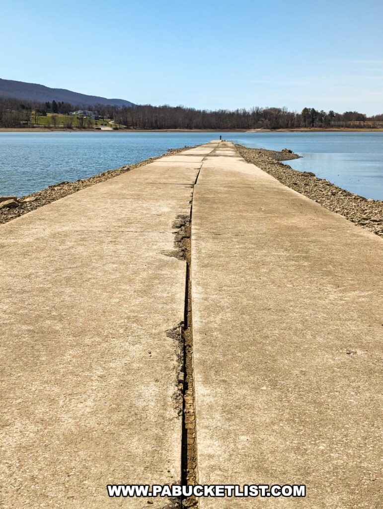
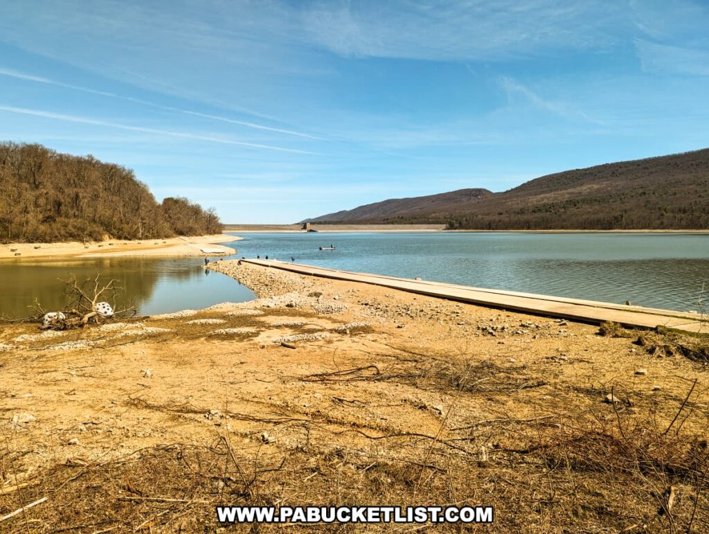
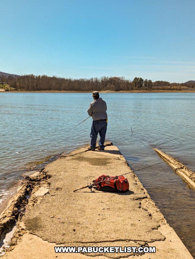
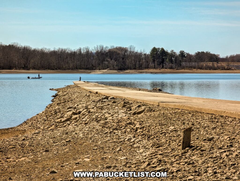
Meaning the sunken highway that normally resides under 20-30 feet of water can be seen and walked on (barring a flooding rain/snowmelt) from late December through mid-April.

The concrete remains of the Sunken Highway extend into the tranquil waters of Sayers Lake at Bald Eagle State Park, providing a striking linear perspective against the natural surroundings. A single figure stands in the distance on the road, framed by the expansive blue sky and the serene lake, with the gentle rolling hills and the outline of a community near Howard, PA, providing a picturesque backdrop.
The concrete remains of the sunken highway extend into the tranquil waters of Sayers Lake.

A few sections of the old highway can be seen year-round, as they were repurposed as either park roads or hiking trails.

A narrow concrete path stretches ahead, flanked by the barren branches of early spring trees and shrubs under a clear blue sky. This former roadway, known as the Sunken Highway, now serves as a tranquil walking trail. The centerline, a faded reminder of its past, leads the eye forward, while the surrounding nature hints at its reclamation by the landscape. Shadows of the trees stripe the path, adding a rhythmic pattern to the scene. This tranquil pathway offers a unique blend of history and nature at Bald Eagle State Park.
A portion of the old highway now repurposed as a hiking trail.

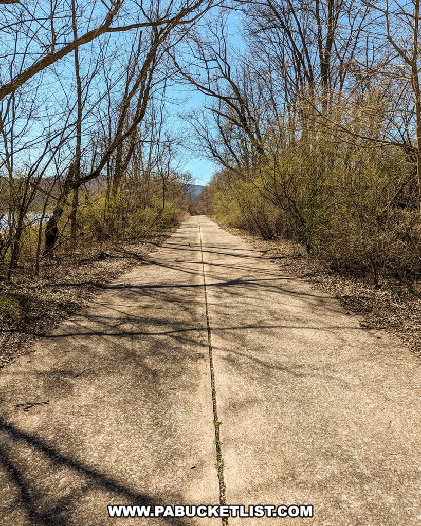
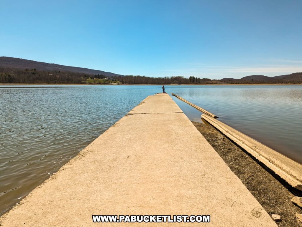
But it’s the normally-submerged portions of the highway that draw both sightseers and anglers alike.

The image showcases the historic Sunken Highway at Bald Eagle State Park near Howard, PA, a straight concrete road that cuts across Sayers Lake. Visitors can be seen on either side of this once-submerged stretch of Old US Route 220, enjoying the unique landscape where the road divides the water, leading the eye toward the distant tree-lined shore and blue sky above.
The sunken highway becomes a temporary fishing pier when the water levels are drawn down.

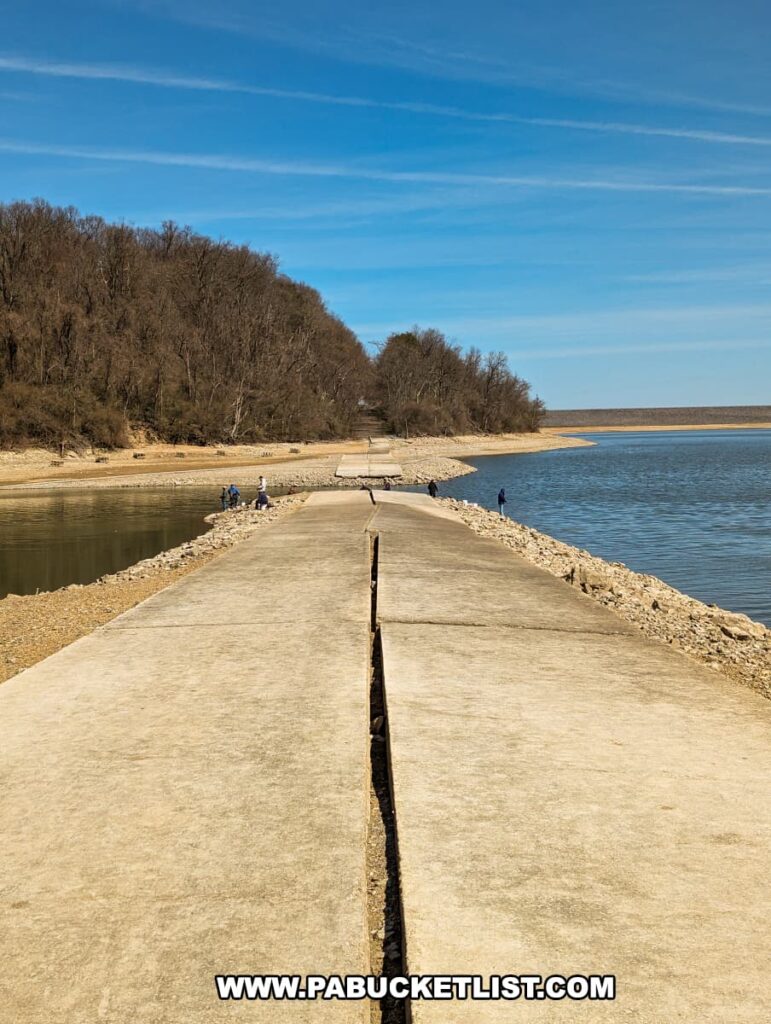
Here’s a view of Sayers Dam in late March, with the water levels drawn down.

A portion of the old Sunken Highway emerges from the shores of Sayers Lake, cutting a concrete swath through the water and stretching towards the dam in the distance. This abandoned section of US Route 220, now part of the picturesque landscape at Bald Eagle State Park, is bordered by the natural textures of sand and dried grasses. The serene waterway is fringed by hills, reflecting the calm, clear sky, and a few visitors enjoy the unique setting on a sunny day.
Sayers Dam in the top-center of the image.

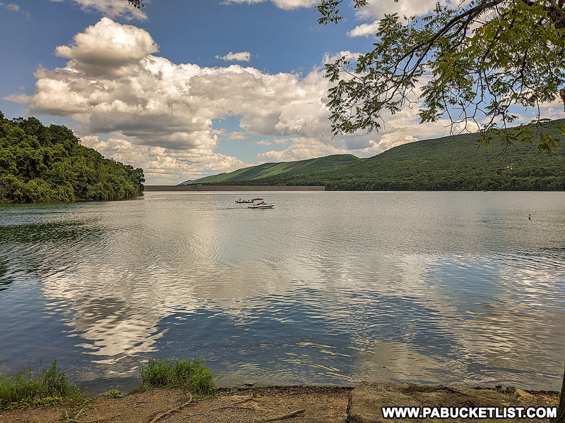
And here’s that same view of Sayers Dam at the normal summer water levels – no road visible!

Sayers Dam at Bald Eagle State Park.
Sayers Dam at Bald Eagle State Park, with the sunken highway now submerged under 20-30 feet of water.

Anglers in particular enjoy this time of year, as the sunken highway becomes a seasonal fishing jetty.

A person stands fishing at the end of the Sunken Highway at Bald Eagle State Park, with a fishing rod in hand and a tackle bag resting on the concrete path. The old stretch of US Route 220 extends into Sayers Lake, surrounded by calm waters and a peaceful landscape under a clear blue sky. The road, showing signs of decay and resilience, offers a unique fishing spot, blending history with leisure against the scenic backdrop of the park.
Fishing from the “end of the road”.

But no matter if you’re an angler of just someone with cabin fever looking for an interesting late winter/early spring outing, check out the sunken highway at Bald Eagle State Park, and immerse yourself in bit of Centre County history!

An exposed strip of the old Sunken Highway curves along the edge of Sayers Lake at Bald Eagle State Park, creating a stark contrast with its surrounding rugged terrain and the calm blue waters. People and a fishing boat are visible in the distance, enjoying the tranquil outdoor setting. The remnants of the abandoned highway, once submerged, are now a testament to the area's history, while the natural beauty of the park provides a serene backdrop.
The sunken highway is an interesting seasonal attraction at Bald Eagle State Park.

Exploring Bald Eagle State Park in Centre County is your guide to all the best things to see and do at the park throughout the year.

The beach at Bald Eagle State Park.

30 Must-See Attractions in Centre County is your guide to even more great things to see and do near Bald Eagle State Park.

The best things to see and do in Centre County PA.
Scenes from Centre County.

If all things “old and abandoned” interest you, be sure to check out my article 34 Abandoned Places in PA You Can Legally Explore.

The western portal of Rays Hill Tunnel along the Abandoned PA Turnpike
The abandoned PA Turnpike.

Did you enjoy this article?

If so, be sure to like and follow PA Bucket List on Facebook, Instagram, and/or Pinterest to learn more about the best things to see and do in Pennsylvania!

Click on any of the icons below to get connected to PA Bucket List on social media.


PA Bucket List 2022 Sasquatch Logo

Pennsylvania’s Best Travel Blog!

Rusty Glessner
Rusty Glessner is a professional photographer, lifelong Pennsylvanian, and a frequently-cited authority on PA's best travel destinations.