![Exploring-Wolf-Rocks-in-the-Gallitzin-State-Forest Exploring Wolf Rocks along the John P Saylor Trail in the Gallitzin State Forest.](https://pabucketlist.com/wp-content/uploads/2022/12/Exploring-Wolf-Rocks-in-the-Gallitzin-State-Forest-696x584.jpg)
If you’re looking for directions to Wolf Rocks in the Gallitzin State Forest, you’re in the right place!
![The view from just south of Wolf Rocks in the Gallitzin State Forest.](https://pabucketlist.com/wp-content/uploads/2022/12/Wolf-Rocks-Gallitzin-State-Forest-Near-Windber-Pennsylvania.jpg)
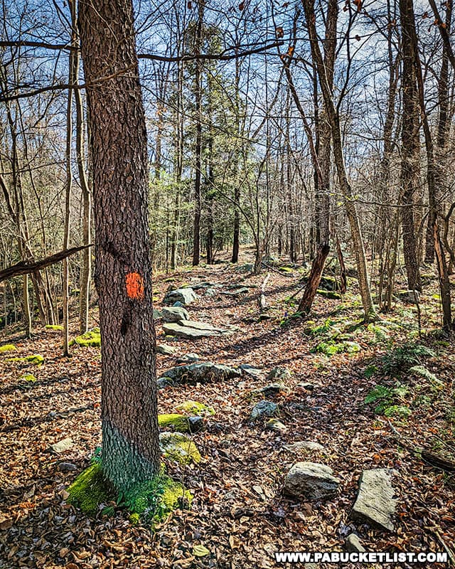
Wolf Rocks is a beautiful geological formation located along the orange-blazed John P. Saylor Trail in the Somerset County portion of the forest.
![The orange-blazed John P Saylor Trail leading to Wolf Rocks in the Gallitzin State Forest.](https://pabucketlist.com/wp-content/uploads/2022/12/Wolf-Rocks-Gallitzin-State-Forest-Somerset-County-Pennsylvania-John-P-Saylor-Trail.jpg)
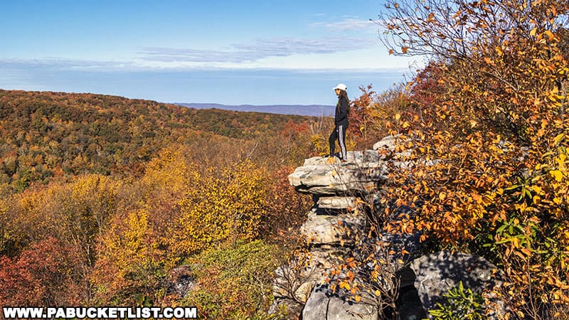
Don’t confuse this Wolf Rocks with the Wolf Rocks Overlook in the nearby Forbes State Forest (pictured below) – these are two totally different locations.
![Fall foliage views from Wolf Rocks Overlook in the Forbes State Forest on October 16, 2022.](https://pabucketlist.com/wp-content/uploads/2022/10/Wolf-Rocks-Overlook-Forbes-State-Forest-Westmoreland-County-PA.jpg)
Directions to Wolf Rocks in the Gallitzin State Forest
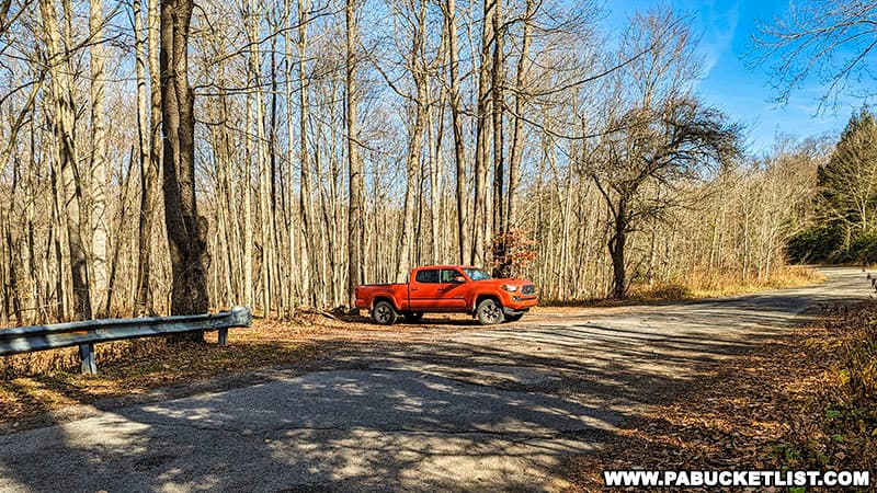
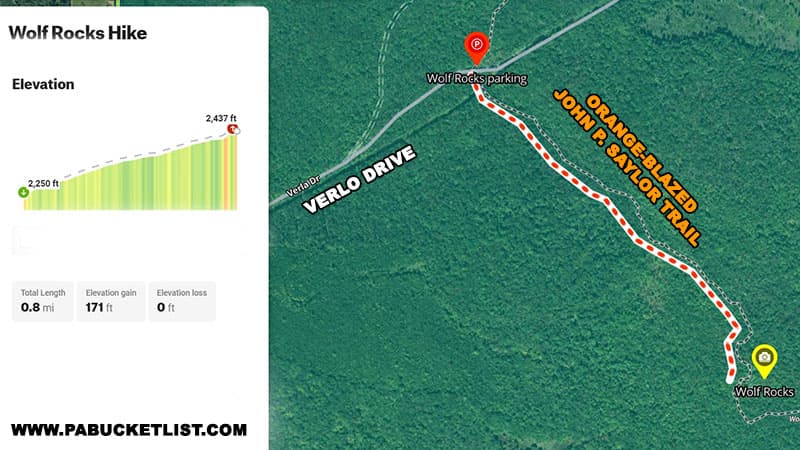
The trailhead for the Wolf Rocks hike as I’m going to describe it is located along Verla Drive, a mile in off of Route 56 (see map below).
![How to find Wolf Rocks in the Gallitzin State Forest.](https://pabucketlist.com/wp-content/uploads/2022/12/Map-to-Wolf-Rocks-Gallitzin-State-Forest-Somerset-County-Pennsylvania.jpg)
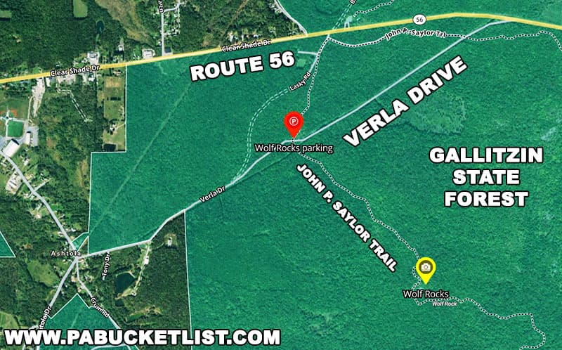
The parking area is located next to a small bridge at GPS coordinates 40.21068, -78.76487.
![The parking area along Verla Drive for the hike to Wolf Rocks in the Gallitzin State Forest.](https://pabucketlist.com/wp-content/uploads/2022/12/Wolf-Rocks-Gallitzin-State-Forest-Somerset-County-Pennsylvania-parking-area.jpg)
The hike begins on the side of the road opposite the parking area, and follows the John P. Saylor Trail for 0.8 miles to the rock formation.
![A map showing the John P Saylor hiking trail leading to Wolf Rocks in the Gallitzin State Forest.](https://pabucketlist.com/wp-content/uploads/2022/12/Wolf-Rocks-Gallitzin-State-Forest-Hike-Details-Map.jpg)
Exploring the Rocks
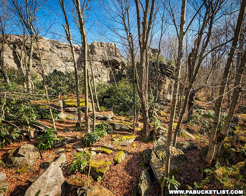
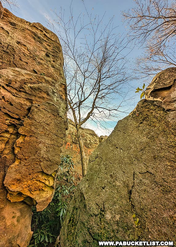
Wolf Rocks is an oblong-shaped formation of boulders that seem to jut up from the Earth to heights as great as 30 feet above the surrounding forest.
![Moss covered boulders at Wolf Rocks in the Gallitzin State Forest.](https://pabucketlist.com/wp-content/uploads/2022/12/Wolf-Rocks-Gallitzin-State-Forest-Pennsylvania.jpg)
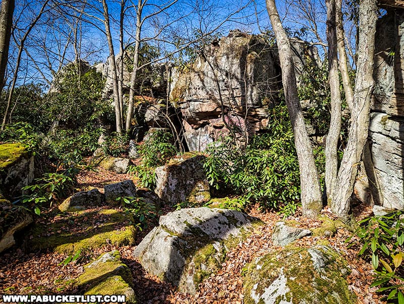
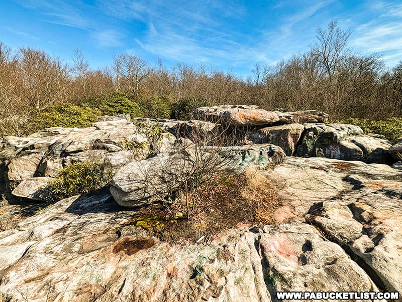
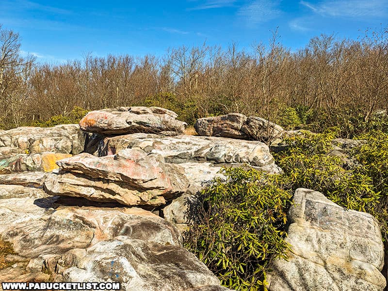
Between these boulders you’ll find all sorts of mini-caves and crevasses.
![Wolf Rocks in the Gallitzin State Forest contains many crevasses and small caves.](https://pabucketlist.com/wp-content/uploads/2022/12/Wolf-Rocks-John-P-Saylor-Trail-Gallitzin-State-Forest-Somerset-County-Pennsylvania.jpg)
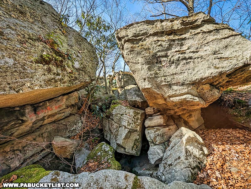
There is no “official” trail around the perimeter of Wolf Rocks, but it’s easy to pick out numerous “user trails” to make you way around as well as through some of the crevasses at Wolf Rocks.
![A crevasse at Wolf Rocks in the Gallitzin State Forest.](https://pabucketlist.com/wp-content/uploads/2022/12/Wolf-Rocks-Gallitzin-State-Forest-Somerset-County-PA.jpg)
On the northeast side of Wolf Rocks you’ll find a path that leads out on top of the formation.
![The top of Wolf Rocks is easily accessible from this point at he north edge of the rock formation.](https://pabucketlist.com/wp-content/uploads/2022/12/Wolf-Rocks-John-Saylor-Trail-Gallitzin-State-Forest-Somerset-County-Pennsylvania.jpg)
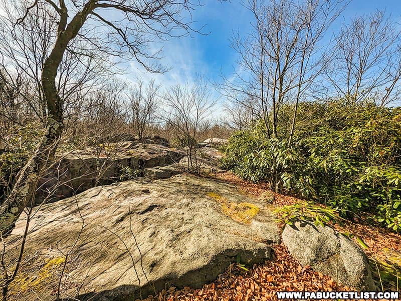
Use caution as you explore the top of Wolf Rocks, especially if you choose to step over some of the smaller crevasses.
![Wolf Rocks along the John P Saylor Trail in Somerset County Pennsylvania.](https://pabucketlist.com/wp-content/uploads/2022/12/Wolf-Rocks-John-Saylor-Trail-Gallitzin-State-Forest-Somerset-County-PA.jpg)
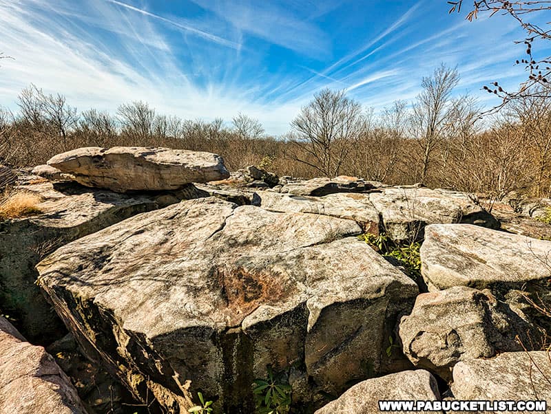
The top of the rock formation is roughly 60 yards across at it’s widest point.
![Standing on top of Wolf Rocks in the Gallitzin State Forest.](https://pabucketlist.com/wp-content/uploads/2022/12/Hiking-to-Wolf-Rocks-Gallitzin-State-Forest-Somerset-County-Pennsylvania.jpg)
There is a partial view of the horizon to the southwest, but the surrounding trees prevent this from being much of a scenic overlook.
![The view from Wolf Rocks, looking to the southwest in the Gallitzin State Forest.](https://pabucketlist.com/wp-content/uploads/2022/12/John-P-Saylor-Trail-Wolf-Rocks-Gallitzin-State-Forest-Windber-PA.jpg)
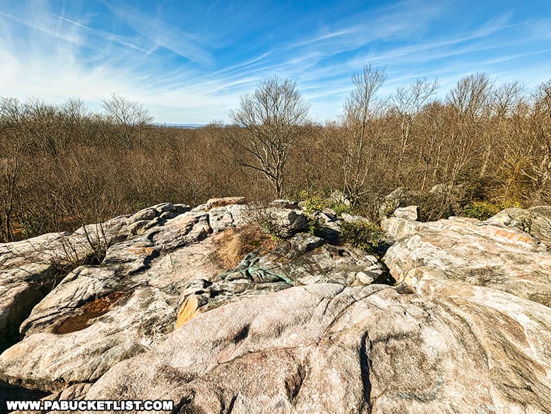
There is, however, an unobstructed view of the sky, making Wolf Rocks a great place to visit if you just want to soak up the sun in a relatively secluded environment.
![A portion of Wolf Rocks in the Somerset County portion of the Gallitzin State Forest.](https://pabucketlist.com/wp-content/uploads/2022/12/Wolf-Rocks-Gallitzin-State-Forest-Somerset-County-PA.-John-Saylor-Trail.jpg)
Nearby Attractions
The Clear Shade Creek swinging bridge serves as a connector between the 2 loops that make up the John P. Saylor Trail in the Gallitzin State Forest.
![Hiking to the Clear Shade Creek swinging bridge in the Gallitzin State Forest.](https://pabucketlist.com/wp-content/uploads/2022/12/Hiking-to-Clear-Shade-Creek-Swinging-Bridge-Somerset-County-PA.jpg)
County Line Vista is located right along the Somerset-Bedford county line in the Gallitzin State Forest.
![How to find County Line Vista in the Gallitzin State Forest.](https://pabucketlist.com/wp-content/uploads/2021/06/County-Line-Vista-Gallitzin-State-Forest-Somerset-County-PA.jpg)
Skyline Drive Vista is a picturesque roadside overlook in the Gallitzin State Forest.
![The overlook platform at Skyline Drive Vista in the PA Laurel Highlands.](https://pabucketlist.com/wp-content/uploads/2021/06/Skyline-Drive-Vista-Gallitzin-State-Forest-Somerset-County-PA.jpg)
The Lost Children of the Alleghenies Monument preserves the tale of the tragic disappearance of 2 young brothers and the mysterious circumstances by which they were found.
![How to Get to the Lost Children of the Alleghenies Monument and Burial Site in Bedford County, PA](https://pabucketlist.com/wp-content/uploads/2022/10/Lost-Children-of-the-Alleghenies-Monument-and-Burial-Site-Blair-County-PA.jpg)
Pavia Overlook at nearby Blue Knob State Park is located atop the second-highest mountain in Pennsylvania!
![Exploring Pavia Overlook at Blue Knob State Park in Pennsylvania.](https://pabucketlist.com/wp-content/uploads/2022/06/Exploring-Pavia-Overlook-at-Blue-Knob-State-Park.jpg)
17 Must-See Pennsylvania Rock Formations is your guide to even more great spots to check out in “Rocksylvania”!
![The author in one of the canyons formed by massive rock formations along the Fred Woods Trail.](https://pabucketlist.com/wp-content/uploads/2021/04/Fred-Woods-Trail-Rock-Garden-City-Canyon-Cameron-County-PA.jpg)
Did you enjoy this article?
If so, be sure to like and follow PA Bucket List on Facebook, Instagram, and/or Pinterest to learn more about the best things to see and do in Pennsylvania!
Click on any of the icons below to get connected to PA Bucket List on social media.
![PA Bucket List 2022 Sasquatch Logo](https://pabucketlist.com/wp-content/uploads/2022/01/PA-Bucket-List-Sasquatch-Logo-small.png)